06 November 2013

Mile Hammock Bay to Carolina Beach: Ya Shoal Gotta Be Careful

As mentioned in yesterday's post, navigating the ICW requires a lot of attention. On most GPS chart plotters, the route is marked with a magenta-colored line, but it is recommended that boaters not strictly follow this magenta line due to frequent changes to the depth of the channel caused by shoaling.

Luckily there are many navigational aids along the ICW, placed and maintained by the U.S. Coast Guard (USCG) or by private individuals or organizations who have obtained permits from the USCG.  The aids are mostly in the form of day boards that are red or green and mounted on pilings.

Conventionally, a boater keeps aids that are red to starboard when returning from the open sea or heading upstream.  Since the ICW frequently crosses or joins other waterways, it has its own unique symbols, a yellow reflective mark placed on each day board or buoy.  When heading south, a yellow square marks port and a yellow triangle marks starboard.

To address the shoaling problems in the ICW, the Coast Guard will place small, floating navigational aids on problematic shoals, and it is known that you should avoid getting too close to these.

Unfortunately, even with all the navigational markers out there, running aground is one of those things that just happens.

Sometimes it's because you just aren't being as careful as you could.  This happened to what I will call Vessel Aground #1 this morning, just as it was leaving Mile Hammock Bay.  We later chatted with that boat's captain and first mate and when Jamey commented, "You just hadn't had your coffee yet," the captain agreed.   "Tea," said the first mate, "I hadn't had my cup of tea yet."  They had declined Jamey's offer of a pull when we passed them early this morning, and luckily were able to free themselves by winching the boat off using a stern anchor.

I'm not exactly sure what the circumstances were for Vessels Aground #2 and #3, but I will blame it on that fearsome menace, Big Bad Shoal (BBS).  BBS takes the blame because I am assuming that like C.Spirit, Vessels Aground #2 and #3 have careful captains and relatively good navigational charts and tools.  The thing with BBS is that he creeps and crawls out and sucks your keel in EVEN when you are watching out for him.  Sometimes he recruits his evil friends, Big Bad Wake or Big Bad Wind.  Sometimes, it is when a captain is kindly giving room to a barge or other large vessel, that BBS is opportunistic, and seizes the moment...and keel.   

We passed Vessel Aground #2 by one of the floating green cans, marking an encroaching shoal at the mouth of an inlet.  Sadly, it was hard aground, fixed sideways to the current and starting to keel over a little.   As we moved down the river, a towboat rushed to its rescue, and we hope Vessel Aground #2 was able to be pulled off without damage.

We heard about Vessel Aground #3 over the VHF shortly after it ran hard aground at the turn into Wrightsville Beach in a channel known for persistent shoaling despite frequent dredging. 

We later heard from some folks who had traveled our same route yesterday that they had also seen three boats go aground along the way.  We made it to our anchorage safely and without incident, but our fear of BBS and his gang definitely grew.

PB060182
Some navigational aids are more visible than others. 

PB060186
Wrightsville Beach
____________

WHERE WE STARTED: Anchored in Mile Hammock Bay, Mile 244

WHERE WE ARE: Anchored in Carolina Beach Bight, Mile 294

FROM THERE TO HERE:  50 miles, 7.5 hours, Jamey at the helm.  We traveled with around 5 or 6 other boats, at times everyone lined up in a row, looking like the "Gotta-Get-South Parade."  At the end of the day, we had crew from several boats visit us.  The passage down had been a sort of bonding experience for everyone, and it was great to be able to rehash the day.  

PB060180
Waiting for the bridge to open.  Jamey circled around; other boats were less hyper. 
PB060185
The parade of boats
Pink!

05 November 2013

Bogue Sound: One Aground and One Submerged

No, not us.  But crossing through Bogue Sound was definitely a pain in the…stern.

Bogue Sound is a shallow body of water located along a section of the coast of North Carolina lying north of the Bogue Banks.  The land along these banks is thought to be that which Florentine explorer, Verrazzano, describes in a letter dated July 8, 1524, as "a new land never before seen by any man, either ancient or modern."   Verrazzano is the first European to sail the coast of America from Florida to Newfoundland, and this document is the first written reference to America.

Verrazano's letter is apparently quite extensive in his geographical and topographical description of the North Atlantic coast of America. In addition to cartographic depictions of the coastlines, he also included meticulous nautical and astronomical data and further provided detailed descriptions of various Indian tribes.

Despite Verrazzano's accomplishments, he erroneously described and drew the vast Pamlico Sound, west of North Carolina's Outer Banks, as the Pacific Ocean.  Cartographers were thus misled for the next fifty years, with the Sea of Verrazano believed to be an easily traversed connection to the west.

Writings from Verrazzano's journey also describe the kidnapping of an eight-year-old Indian child (in some accounts described as a boy, in some as a girl) who Verrazzano brought back to France, and I wonder how this child fared and hope he or she was treated well.  

The Bogue Sound is traversed by the Intracoastal Waterway (ICW) in an east to west direction.  As we traveled its course today, we passed many dredge spoil islands, artificially created islands that cover nearly 400 acres within the Sound.  Many of the islands are over 50 years old.  These older islands sport mature trees and shrubs while younger ones are bare sand.  The dredge spoil islands, marshlands and sand shoals within Bogue Sound provide extensive habitat for many populations of birds and aquatic life.  
PB050165
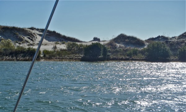
We passed many of these beautiful dune-topped islands on our port side.  The starboard side was lined with occasional communities of waterfront homes.

The Sound is beautiful.  Its configuration, however, with multiple inlets allowing ocean currents to move in and out and deposit sand or silt, creates navigation hazards.  This is what I was referring to above as a pain in the "butt butt" (as the girls would say).
IMG 7410
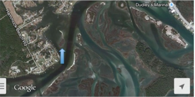
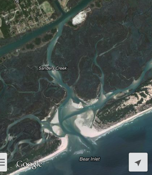
This Google image shows the narrow, dredged ICW route crossing the top left corner.  The Bear Inlet provides an opening for sediment to be carried inland.  You can see the shoaling that is encroaching into the ICW channel. 

The ICW through the Sound is dredged regularly by the Army Corps of Engineers, last occurring in 2010.  If only it could be dredged wider.  Motorsailing through the Sound today required a ton of attention to stay in its narrow channel.  Fortuitously, there was a sailboat ahead of me that I was able to follow closely.
 
One of the boats that I refer to in my title was a sailboat that we passed aground on a small shoal just past the hook of the ICW where it passes Swansboro.  The ICW route here turns initially slightly northwest and then south for a short distance.  This southward heading made the point of sail less of a broad reach than we had been on all day and more of a beam reach (a sideways-to-the-wind direction).  With the big gusts of NE wind, we were prone to the wind pushing us towards the leeward side of the channel, and this may have contributed to the other boat going aground.    

As I approached the boat that was aground, I called to Jamey, who came up and went into action mode, pulling in the jib and telling me to head up to stop the boat.   Having been down below, he thought the boat aground may have been the boat whose path I had been trailing all day.  I reassured him that it was not, and we continued on with a shortened jib and heightened caution.

NewImage
The blue arrow points to the boat aground.  With sparse channel markers and a wide stretch of water, you can see how it is tricky figuring out exactly where the narrow ICW channel is.  The boat's crew was already off the boat when we passed.  

NewImage
It looks like the boat was aground on the shoal located at the tip of the arrow.  The shoal probably shows itself at low tide, but was not at all visible when we passed by it. 

Farther along, we had another incident where we again realized that the "environmental awareness" of whoever is at the helm is of great value.  We had been anticipating the area along Mile 238 at Browns Inlet which is prone to shoaling.  Though dredged in 2010, it was known to have shoaled to depths of six feet at mean low water in spring of 2012.  We had been cautioned by the guidebooks to favor the starboard side of the ICW in this area.  As we passed Mile 238, Jamey directed me to move farther towards the right side of the channel than I was comfortable with, and at one point we softly scraped the keel with readings of 3.1 on our depth sounder.  

We later discussed how the person at the helm has the benefit of time and focus given to reading the water, the canal banks, and other environmental clues that should not be discounted even in light of guidebook advice or the urgings of more experienced crew.  

Okay, if I've kept your attention this far, you must be interested in the submerged vessel.  Shortly after we left Beaufort, we heard someone via VHF acknowledge the Coast Guard chopper that passed overhead, thanking it for its service and informing us that the chopper had just been involved in a "life-saving effort." We later heard broadcasts throughout the day of a new obstruction south of Atlantic Beach, and in the later portion of the day, the broadcasts referred to this obstruction specifically as a submerged sailing vessel.

By looking at the Coast Guard's newsroom (access here but watch out for getting enticed into reading about all the rescue or search efforts currently taking place), we found that the newly submerged sailboat was probably Dove, a 28-foot vessel that started taking on water around 7:15 am this morning.  Thankfully, the rescue effort was successful, and the 51-year-old captain of the boat was rescued by 8:15 am from his life raft around 20 miles south of Atlantic Beach.

Hearing the Coast Guard broadcasts and seeing the boat aground in the ICW today reminded us that we remain always vulnerable to the power of the sea and land.  We tightened our watch on ensuring that we and the girls are always tethered and with life jackets on when underway.

We remain in constant admiration of and forever grateful for the heroic work performed by the Coast Guard.   We offer our hopes that the boat aground was able to be freed easily, and that Dove will be able to be recovered.
_________________

WHERE WE STARTED: Taylor Creek, Beaufort, N.C., Mile 204.

WHERE WE ARE:  Anchored in Mile Hammock Bay, around Mile 245, a basin dredged by the military for use with Camp LeJeune.  There is a really wide boat ramp here that looks like it might be used for troop-landing exercises.  Civilians are prohibited from going ashore.  Good hold.  There are around 10 other boats anchored here tonight with ample room for us all. 

THERE TO HERE: Around 40 miles, 6 hours.  Nancy at the helm.

We had tidal currents to contend with, and luckily they were mostly in our favor.  As the tide floods or ebbs in and out of the inlets of Bogue Sound, the water can move through the Sound and ICW with much force.  Our speed varied from less than 5 mph to a max of 10.1 mph depending on where we were in relation to the inlets and the tide.  It was a NE wind with gusts in the lower 20s, and we motorsailed with the jib almost entirely on a broad reach throughout the day.

From Miles 235 to 241, we passed through Camp LeJeune,  a Marine Corps military reservation that can sometimes close the ICW for several hours due to artillery firing and amphibious landing exercises.  We only saw a couple of marines with some rods doing some fishing "exercises."  We heard lots of artillery firing and bombing throughout the day and night.

The Onslow Beach Swing Bridge at Mile 240.7 is owned and operated by the Marine Corps and opens on the hour and half-hour from 7:00 am to 7:00 pm.  As we arrived, we heard a waiting boat ask the bridge tender for an estimated opening time as it seems they had been waiting for over an hour. The bridge swung open as we got closer, and it seems that the tender may have been  waiting for us (the last boat in this clump of vessels), perhaps because it is a slow bridge to open.  Thank you, Bridge Tender!

PB050170
The channel leading into Mile Hammock Bay.  Those markers are not to be ignored!

04 November 2013

Beaufort, N.C.: The North Carolina Maritime Museum

When you are living on a boat, the places that you visit are inevitably defined by proximity to water.  This has been true for most of the museums that we have visited over the past couple of months.

"Another maritime museum?!" remark the girls.  Yes, five or six already.  The girls have studied and climbed aboard dugouts, skipjacks, schooners, tugboats, and whaleboats.  They are well versed in the many trades of those who work on the water including oystermen, crabbers, fishermen, maritime pilots and pirates.  They have visited historic sites preserving or replicating seaside communities and learned about their tradespeople including sailmakers, boatbuilders, crab pickers, and chandlers.  We have even "lived" on the grounds (or technically, at the docks) of the Mystic Seaport in Connecticut, able to walk around the museum campus at night.

"Maritime museum overkill," complains Phoenix.  Nonetheless, to maritime museums we continue to go.  We have found that each locale lends a unique perspective on history, and every museum has had its own special offerings for us. 

At the North Carolina Maritime Museum in Beaufort, there were a few things that caught our attention.

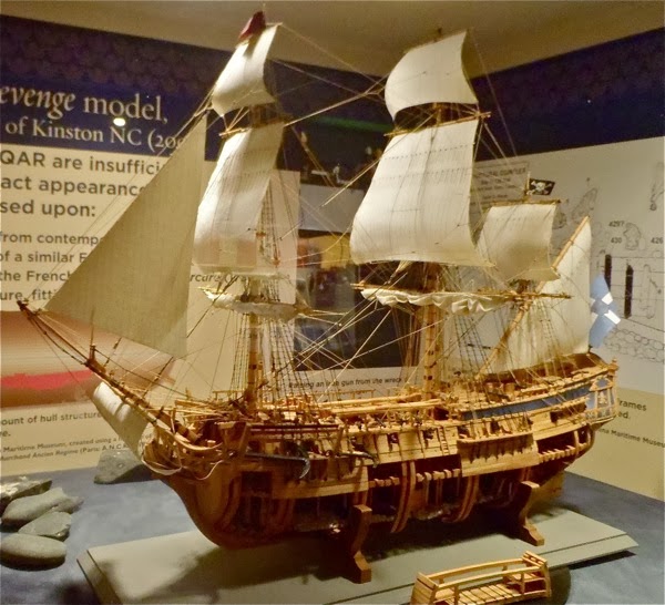
The obvious one was the exhibit on Blackbeard's ship, Queen Anne's Revenge.  Discovered in 1996 just 25 feet underwater and a mile and a quarter off the North Carolina shore, the shipwreck site of Queen Anne's Revenge has had over 16,000 artifacts unearthed with excavation still ongoing.  The renown of her captain, the ferocious pirate Blackbeard, has been better personalized by shipwreck findings such as cuff links, cannons, and even what is believed to be part of his toilet.  

What I like about Blackbeard is that he was known as being sort of a "Gandhi" of pirates, practicing non-forceful thieving and piracy.   He was able to be successful at this nontraditional form of his trade using that most powerful of weapons, his reputation.   Unlike Gandhi, his nonviolence was not motivated by moral or spiritual philosophy, but rather by practical considerations of wanting to keep the cargo and ships he was plundering from being damaged.

PB040124
A model of the Queen Anne's Revenge

PB040126
A diorama of the excavation site

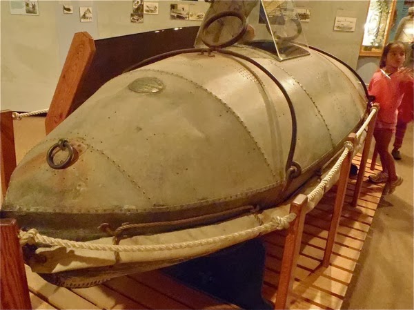
Another display in the museum that caught our eye was that of a life car, a submarine-esque pod that could be used to save people from shipwrecks if the wrecks were close enough to shore and if the water was too rough for the life-saving boats of that time.  The life cars could be pulled over or through difficult water, transporting people inside its shell.  Sounds great, but looking at the heavy life car with its small, enclosed space, I could not imagine having to move or ride in such a vessel.  

Basically, a small line would be shot out to the shipwreck from the shore, then a larger line would be pulled out and attached to the ship's mast.  Back on shore, the line would be pulled taut using oxen or whatever means was available.  The life car could then be pulled back and forth between shore and ship, transporting survivors to safety.  Initially, the life cars did not have ventilation holes and were known to only have only a few minutes of oxygen available once sealed.

PB040117
The Life Car

I'm not a rescue expert, but I see a lot of "holes" (or not enough) in the life car as a life-saving device.   Indeed, the life car was eventually replaced by the breeches buoy, a much lighter contraption consisting of a life preserver with canvas pants attached that one person could climb into and be pulled to shore on the same sort of set up used to pull the life car.

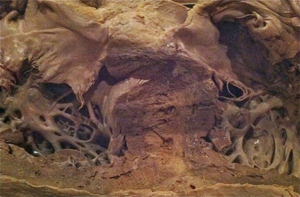
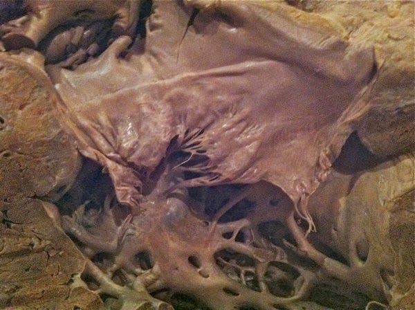
Another heart-stopping (ok,not really, but I couldn't resist) exhibit was a model of the heart belonging to a sperm whale named Echo.  The whale heart's anatomy is similar to ours with a four-chamber heart that pumps through two circulation systems (main and pulmonary).  Unlike humans, some whale hearts can be the size of an automobile, and their cardiorespiratory system is much more efficient than ours.

Whale lungs can extract more than 80 percent of the oxygen carried by blood as opposed to humans who can extract maybe a quarter of this.  Whales are also believed to be able to avoid decompression sickness as they dive and ascend due to their compressible lungs.  Under pressure, their flexible rib cages collapse and push air up into large and impermeable nasal passages, preventing toxic nitrogen bubbles from entering their blood vessels.

IMG 7395
I could not help but imagine having to do CPR on this

IMG 7397
I would love to see this heart contract -- imagine the power it must have to be able to pump blood through the entire whale

IMG 7398
You would have to climb into the heart to do any cardiac surgery. 

It was another great visit to a maritime museum, even for the girls!

PB040131

INDIGO'S POST: MUSEUM!

When we walked in, we went to the desk and they gave us a sheet of paper that was a truasher hunt.  In the lobby there were two woden bords that were filled with fish.  There were dolphins, sharks, a lobster, skeletons.  We started our scavanger hunt in the lobby than we went in the gift store and got about 6 to 7 bandanas and littel metal sea ornaments.  There were sea stars, shells, fish, crabs, etc. Then we walked and we saw this amazing life car that gose out to sea to save people.  This can hold about 11 people bolted shut.

Skye loved working on her scavenger hunt

_______________

WHERE WE ARE: Anchored in Taylor Creek, Beaufort, N.C.

THE NORTH CAROLINA MARITIME MUSEUM:  This museum system is made up of the North Carolina Maritime Museum at Beaufort, the Graveyard of the Atlantic Museum in Hatteras, and the North Carolina Maritime Museum at Southport.  Admission is free.  The museum is located at 315 Front Street, an easy walk from the town dinghy dock that takes you past many fun and shopping-worthy nautical-themed gift and clothing stores.  Hours are Mon-Fri 9 am to 5 pm, Sat 10 am to 5 pm, Sun 1 pm to 5 pm.

EXCELLENT POST-MUSEUM BREAK: The Beaufort Coffee Shop and Cru Wine Bar -- Totally relaxed and mellow ambience.  Quality coffee, great menu with tempting offerings, and an extensive selection of specialty wines and ales.  What more do you need?  Chocolate? Yup -- made by them.  WiFi? Yup.  I loved that you could add a shot of rum, whiskey or brandy in any coffee beverage for only $3 extra.  Located at 120 Turner Street, less than a block away from the museum.

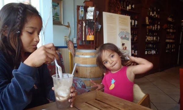
PB040140
Root beer float!


PB040141
Fizzy and creamy!

PB090309
We told the kids it was too spicy to share with them.   
I love it when it's easy to support local!
PARKS AND PROVISIONS: We did not find any playgrounds, but there were many benches and pretty places to relax along the waterfront.  Taylor's Creek Grocery and a laundromat are right in the heart of the town.  There is a Piggly Wiggly around 1.2 miles down Live Oak St.

We had this on homemade biscuits.  Scrumptious berries in every bite. 

03 November 2013

Gale Creek to Beaufort: Breezy Sailing and Heaving To

JAMEY'S POST:

We woke up early this morning in a quiet, well-protected anchorage that we had almost passed.  Motoring along last night, I noticed two other boats anchored just out of the channel, checked the charts and decided it would be a great place for us to stop for the night as well.

We left just after first light under sail headed further south, either to Oriental, N.C. (about 20 miles or hafl a day) or on to Beaufort, N.C. (about 40 miles). The weather forecast called for winds from the northwest between 20 and 25 miles per hour.  Very windy, but  blowing us in the direction we wanted to go.  The blue dashed line on the picture below shows our planned route. We would sail southeasterly out into Pamlico sound, then gradually turn southwesterly around Maw point and into the Neuse River.

Oriental calls itself the sailing capital of North Carolina, and is about 10 miles upriver on the northern shore.  The route to Beaufort continues southward from Oriental across the river, into a creek and then down a long, narrow, dredged canal.

IMG 0677
This is a snapshot from our iPad navigation app. The blue dashed line is our planned route. The app will also record our actual route.
After pulling up the anchor, I quietly rolled out the jib, hoping to let everyone else sleep for a while longer.  In the peace of the sheltered anchorage, it was hard to imagine how windy and rough it actually was out in Pamlico Sound, but once we got away from shore, the wind was strong and the waves were choppy.  C. Spirit sailed near her fastest speed, about 9 miles per hour, but below decks, I knew it was not a comfortable ride with too much rocking and rolling.

Often, the kind of sailing we do as a cruising family is different from how we might sail the boat if we were out without the kids or out racing.   With the little people on board, we like to keep the boat moving along at a good speed, but comfort and not overstressing the boat and its crew are also major factors.

One easy way we make this work is to simply wait for a following wind.  Sailing with the wind is easier on everything; the motion is gentler, wind and wave forces on the boat are smaller, and we can sail straight for our destination with no tacking back and forth.

Another trick we use is to sail with just the jib sail.  The jib pulls the boat nicely downwind on its own, making it easy to steer, and since we can roll up all or part of it with the pull of one rope, it is a simple sail to handle.
PB030096
Sailing with the wind means the flag might want to flap you in the ear if you sit in the wrong spot.
As we made our way around Maw Point, which the guidebook mentions as frequently a rough and difficult stretch of water, I kept telling myself to think of it as being named after Maw as in southern version of Ma and Pop, rather than a gaping Maw waiting to swallow unfortunate mariners. The wind gusts kept getting stronger, and I saw a few wave tops getting blown off sideways which I know means it is blowing in the 30's.  I decided to start slowing the boat down by rolling in some of the jib.  My rule of thumb, a common one I think, is to begin reducing sail and slowing down as soon as I first think of it, so I rolled up about one third of the jib and carried on nearly as quickly as before, with less worry about overstressing the sails or making the girls down below extra sick.

Sailing like this is exhilarating -- the boat surfs the waves, leaving a foamy trail tracing your path through the chaotic seas.

Sailing like this also requires care, since there is no easy option to turn back if you sail into a bad spot. As the gusts continued building, I was counting the miles until we got far enough into the Neuse River to get some shelter from the waves out in Pamlico Sound.  It took about two hours of highly attentive steering to get up into the river and close enough to shore to take a break.

For generations, sailors have paused their boats at sea by setting their sails to work against each other and hold the boat essentially in one spot.  The general name for this trick is "heaving to"  because one way to do it involves pulling (heaving) the tiller to the windward side of the boat, while setting the jib sail on the windward side as well. There are lots of ways to set a boat up to make it basically stop in its tracks so you can take a break, have a nap, make a sandwich and cup of hot coffee, reel in that big fish, or do whatever else needs to be done.  Every boat will heave to slightly differently, and it is a great idea to practice this technique before you really need to do it.  I made C-Spirit heave to by rolling up all but a tiny bit of her sail and then letting her drift slowly (about 2 miles per hour) along with the auto pilot holding her on course just outside of Oriental harbor entrance.  "Macho," the autopilot, had an easy time keeping her on course with minimal battery drain while I went below to check in with the others.

I filmed a short video clip while we were "hove to." You can hear the wind whistling past, but notice the boat is pretty still.

After a bit of clean up and rest, we decided to press on to Beaufort.  It is amazing how much better everyone felt once the boat stopped rushing along at full tilt.
_____________

WHERE WE ARE: Anchored in Taylor Creek, between Beaufort and the Rachel Carson Reserve.  Many boats in the anchorage, including some that look as if they have been here for some time.  Not difficult to find a spot.  Domino's Pizza delivered to the closest crossroads for us. 

WHERE WE STARTED: Bay River, Gale Creek

RACHEL CARSON RESERVE:  Created in 1977 to prevent development of the area into a resort.  The reserve has two nature trails and a boardwalk.  It is home to feral horses (a "wild" horse that is of domesticated ancestry), and we saw several of these horses grazing along the beach where we had just played.   "They are eating our [sand] meatballs," said Skye.  Rachel Carson was a marine biologist and conservationist who wrote Silent Spring, the book that helped start the contemporary American environmental movement.  Jamey was very moved by this book and plans to have Phoenix read it soon. 
A feral horse grazing at the shoreline.

These horses are descendants of horses introduced to the area in the late 1940s.  To prevent overpopulation, female horses receive birth control shots. 
There are lots of oyster beds along the shoreline. 
View of the Taylor Creek anchorage from the Rachel Carson Reserve.  Across the creek is Beaufort. 


02 November 2013

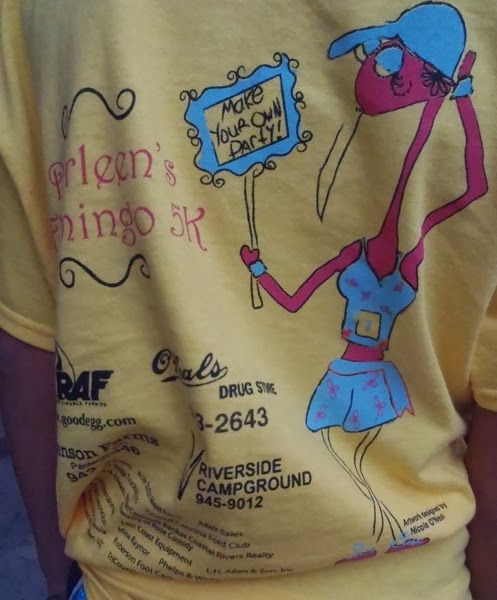
Make Your Own Party: Darleen's Flamingo 5K and K-OS

I'm not usually a fan of organized races.  It seems like running is already torturous enough on its own that rather than paying to enter a race, someone should give ME money to wake up at an ungodly hour and go run with a crowd of overly eager, sweaty people.

Well, no worries today, because the awesome Darleen's Flamingo 5K was not your usual organized race, and I got shunted to babysitting duty with the younger ones so that I wouldn't slow Phoenix down.

Today was the 4th of this annual race that raises money for cancer research, donating the funds raised to the Marion L. Shepard Cancer Center in Washington, N.C.  The race is held in honor of Darleen Smith who died after battling breast cancer.  The motto of the race is "Make Your Own Party," Darleen's favorite saying.

PB020027 
And to the crew that put together this race, I commend you because you guys really know how to put on a party!  When Jamey registered himself and Phoenix early this morning, there were already swarms of volunteers setting up and preparing a huge breakfast.

PB020048
A good ol' southern breakfast!

In addition to the amazing southern food, there was also K-OS playing, a popular local band whose members range in age from 11 years to 14 years.  K-OS was surprisingly good (check them out on Facebook and YouTube), and it was interesting at times to reconcile their "boy next door" look with some of the cover songs that they did, e.g., Joan Jett, Fugazi (and unfortunately it looked like they got censored by mom as they were about to start a Van Halen song).

PB020045 
It was Phoenix's first race ever.  I knew she was fast, but I didn't realize she could run sub-nine minute miles.  Now I understand that she has just been humoring me and running my slow pace on our jogs together. Phoenix ended up placing second in the female under 15 year old division with a time of 27:33 minutes (three seconds behind the 13 year old first place runner), and Jamey placed first in his division.

PB020043


IMG 7384

The race's support buggies
It was sad to leave Pungo Creek, the warm hospitality of Pungo Creek Marina and all those at Darleen's Flamingo 5K, but with the winds set to turn NW for the day, we couldn't ignore the favorable conditions.

As we were all tired from getting up early for the 5K, we had a mellow day with Jamey at the helm, me fishing next to him at the stern of the boat, and the girls mostly doing their own thing down below (remarkably peacefully and with no fights or injuries).

Phoenix spent all afternoon on the ukelele, including using a portion of that time teaching Indigo chords.  The other girls romped, giggled and laughed, loving having command of down under.  It's so fun to Make Your Own Party!

PB020060

PB020059
Our first shrimp boat sightings, a sign of our progress south.


PB020067
Beautiful Sage

PB020070 
PB020077
A beautiful sunset is best enjoyed at the seat on the boat that is farthest away from the kids


PB020090
PB020085
___________

WHERE WE STARTED: Pungo Creek Marina

WHERE WE ARE: Anchored in a beautiful bay on Bay River with a few other boats behind us.

THERE TO HERE: 25 miles, around 4.5 hours, Jamey at the helm.  Sightings today included several dolphins, a beautiful blue heron, and lots of cormorants flying around teasing my fishing abilities with fish in their beaks.


01 November 2013

Pungo Creek Marina: Old Salts, Southern Dogs, and Pink Flamingos

For the past couple of days, we have been anticipating the southwesterly blow that started last night, continued all day today, and is expected to turn westerly tomorrow.  To play it safe, we had found a well-protected anchorage yesterday and had decided to hunker down and not move on today.  Well, as usually happens when we make plans, we did just the opposite.

Being windsurfers, we are not used to sitting still when the wind is up.  On a cruising sailboat, however, it is preferred to make miles when the wind direction favors you and when the wind and seas are calmer.  We passed several other boats in the anchorage as we left this morning, and I swear I thought I saw one of the sailors trying to wave us back.

We motorsailed around ten miles down the Pamlico River, and as it turns out the going was relatively smooth and quite fun.  We furled the main, and with the motor on, had a ton of speed with uneventful sailing and the river all to ourselves save one boat heading north.

Our plan was to move ten miles down, get some gas from the Pungo Creek Marina, and anchor in Pungo Creek for the night.   We didn't follow that plan either, and ended up docking at Pungo Creek Marina due to a "special on the special" that dockmaster Allen offered us.  What a serendipitous move.

Pungo Creek Marina is located around 4 miles south of Belhaven on a quiet and peaceful creek.  The marina has 48 slips, and it looks like in its heyday it must have been the place for boats to be and to be seen.   Unfortunately, Hurricane Irene in 2011 brought a nine foot surge and covered the marina and the whole surrounding area under four feet of water.  Allen told us how he with one of his dogs was sitting on a counter in one of the marina buildings during the storm, watching the waters rise, and thinking, "I could get myself, an old man, up onto the roof if I needed, but how do I get this 80 pound dog up there?!"

The owners have since decided to sell the marina, and it seems to be in a sort of limbo at this time, but of the sort that should not be missed.  Allen's friendliness is hard to describe in words (how do you capture a twinkle of the eye?).  He and the other old salts at the marina entertained us with stories and conversation, and we had multiple offers for rides into town if we needed anything.   The girls loved playing with Allen's dogs, Buffy and Jengo, who showered them with licks and southern dog hospitality.

IMG 7379
Dockmaster Allen at the Pungo Creek Marina

We enjoyed talking to Rocky, a local sailor living on his ketch at the end of the dock and preparing for his trip to the Bahamas.  Rocky is an engineer who has been sailing for more than fifty years and had great tales about sailing around the world.  "I wouldn't do it again...Thirty-six days alone across the Indian Ocean with no company except for a few bugs.  My friend was a praying mantis that liked drinking cola."   He taught the girls that it's important to always know where north is, and teased Jamey about being on a boat with five girls and only one head.

Having checked satellite maps on our phones, we saw that it was too far to walk to Belhaven and too far to walk to anything else.  We were basically docked in the middle of nowhere with only one small neighborhood close by.  We started walking down the empty roads, a fun thing for us to do as the girls can run around and do flips without worry of cars.


IMG 7364
The fabulous four

IMG 7363
C. Spirit is docked in the background behind the razed corn field.

We did not make it very far before we started seeing clumps of pink, plastic flamingos at the edges of the corn fields we were walking by.  Random, right?!  Luckily, we also saw the start and finish markings on the road clueing us into a race that Jamey aptly guessed must have "Flamingo 5K" in its name.

This summer we learned that there is an annual festival in Maine that celebrates the plastic pink flamingo.

IMG 7372
Sage is working on her straddle handstands.  The aftermath of these efforts is not always pretty. 
IMG 7377
Nickel was very genteel.  Dixie, the terrier, ran circles around us.  I told the girls how "Dixie" was on my list of baby names for them. 

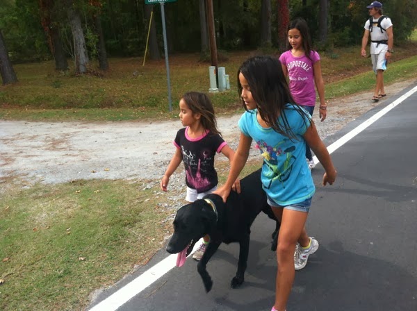
We were able to follow the pink flamingos for a couple of miles, and had the pleasure of being accompanied on our walk by several dogs with the girls' favorites being a mellow black dog named Nickel and a hyper little terrier named Dixie.

The race route is beautiful, and Jamey and Phoenix are planning to run in "Darleen's Flamingo 5K" tomorrow!
______________

WHERE WE STARTED: Crabtree Bay

WHERE WE ARE: Pungo Creek Marina, usually $1 per foot.  The marina currently has an "ICW Southbound Special" going on for $29 per night.  The marina has fuel, water and electricity.  There is a bathhouse for showers.  Rocky told us there used to be a pool on the grounds before it was filled in with a septic system.  Allen said there used to be laundry facilities before the machines were sadly "taken without authorization."

THERE TO HERE:  Ten miles, upwind motorsailing in fun SW wind with gusts to the lower 20s.  Pamlico River has a lot of shoals, so care has to be given to monitoring your depths.  Nancy at the helm.

IMG 7373
This scene makes me a little homesick for my hometown, New Orleans. It's good to be south of the Mason-Dixon line again.